
Veridium Manager introduces powerful geofencing controls, providing administrators with the tools to fine-tune location-based security policies and enhance authentication workflows. This feature offers a new level of granularity and flexibility, allowing organizations to tailor geofencing to their specific needs and security requirements.
Technical details and component diagrams are described in the section Documentation / Top Features / Location aware authentication sessions
Key Features:
-
Comprehensive Geolocation Management:
-
Maintain an up-to-date geolocation database with automated updates and manual upload capabilities.
-
Test the integrity of the geolocation database to ensure accurate location resolution.
-
-
Precise Accuracy Configuration:
-
Define accuracy thresholds to determine the acceptable location precision for authentication attempts.
-
Configure location requirements for mobile devices, such as enabling location services and precise location permissions.
-
Set minimum accuracy levels and maximum wait times for location acquisition to balance security and user experience.
-
-
Customizable UI and Reporting:
-
Control the display of maps in the Self-Service Portal (SSP) and admin session details for enhanced visualization and monitoring.
-
Define the level of detail captured in location data, adhering to GDPR restrictions and privacy considerations.
-
Customize reporting by mapping IP addresses to specific geolocations, improving employee tracking and analysis.
Feature Overview:
-
The geofencing feature is divided into two primary configuration sections:
-
Geolocation - General Tab: Configures various parameters for fine-tuning geofencing behavior.
-
Geolocation - Download Settings Tab: Manages the geolocation database, including update frequency, download URL, manual uploads, testing, and version information.
-
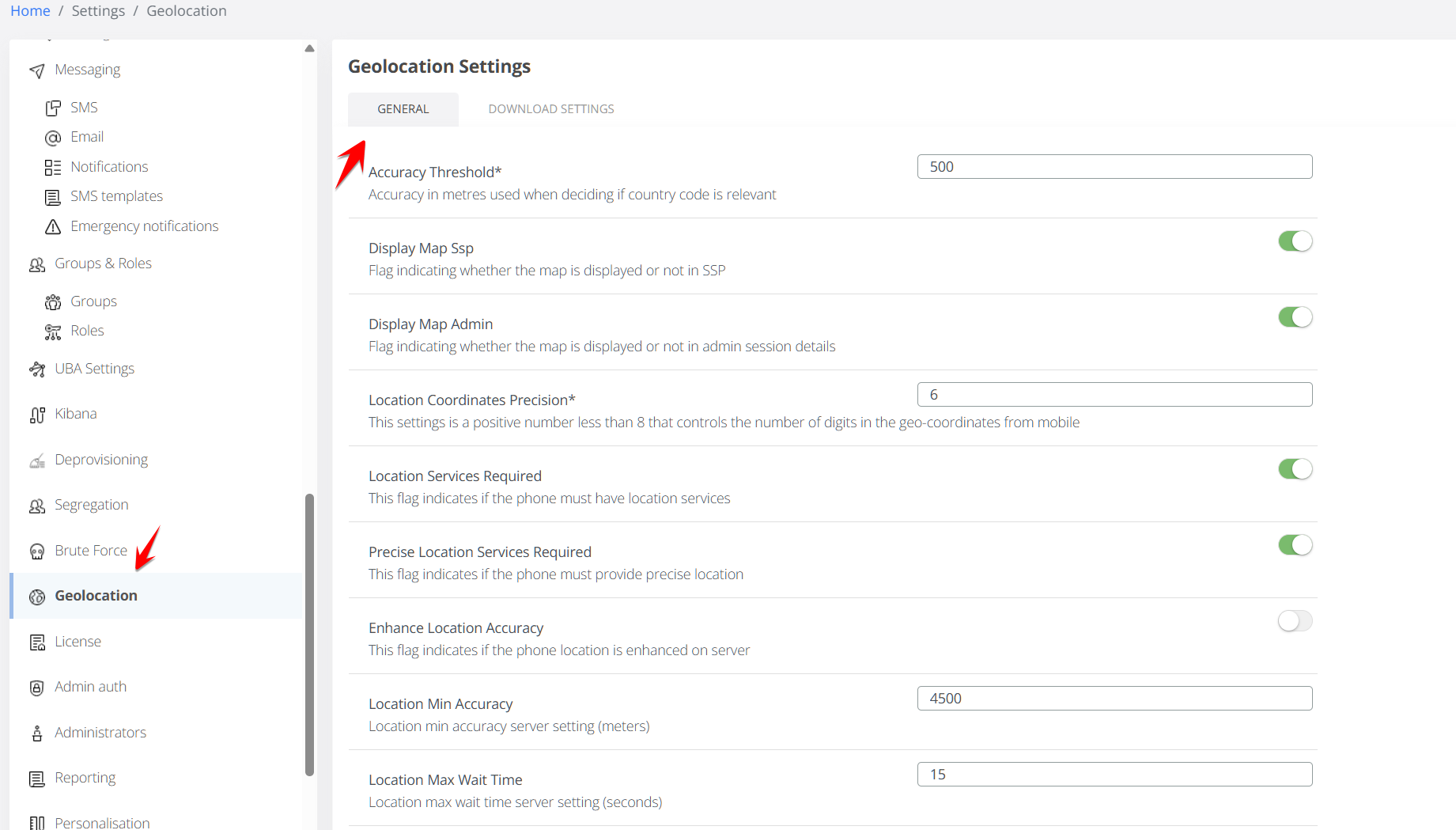
Geolocation - General Tab:
This tab allows administrators to configure various parameters to control geofencing behavior. These parameters can also be edited manually in Admin / Advanced / location.json
|
Name |
Basic Description |
Default Value |
Available starting with version: |
|---|---|---|---|
|
Accuracy Threshold
|
This setting determines the accuracy (in meters) required for a location to be considered valid for country code determination. Use in conjunction with Country Code Replacement parameter below. |
100 (meters) |
3.0 |
|
Display Map Ssp
|
A flag that controls whether the map is displayed in the Self-Service Portal (SSP) |
ON |
3.5 |
|
Display Map Admin
|
A flag that controls whether the map is displayed in the admin session details |
ON |
3.5 |
|
Location Coordinates Precision
|
|
6 |
3.3 |
|
Location Services Required
|
A flag that indicates whether mobile devices must have location services enabled and authorized for use by the mobile application. |
ON |
3.7.2 |
|
Precise Location Services Required
|
A flag that indicates if the mobile device must provide precise location service permission to the Veridium mobile application.. |
OFF |
3.7.2 |
|
Enhance Location Accuracy
|
A flag that determines whether the server dictates the minimum accuracy and wait time for location acquisition. |
OFF |
3.0 |
|
Location Min Accuracy
|
The minimum location accuracy (in meters) required by the server to avoid a "cross-border" tag for a session. |
1000 |
3.0 |
|
Location Max Wait Time
|
The maximum time (in seconds) that the mobile application should attempt to acquire a more accurate location. |
10 |
3.0 |
|
Location Attribute Filter
|
Defines the fields allowed in the location object, based on GDPR restrictions.
|
N/A |
3.2 |
|
Country Code Replacement
|
Specifies the replacement country code to use when the location accuracy is below the configured threshold.
|
XB (cross-border) |
3.0 |
|
Custom Geo Ip Transations
|
Allows administrators to define a custom mapping of IP addresses to geolocations.
|
N/A |
3.2 |
-
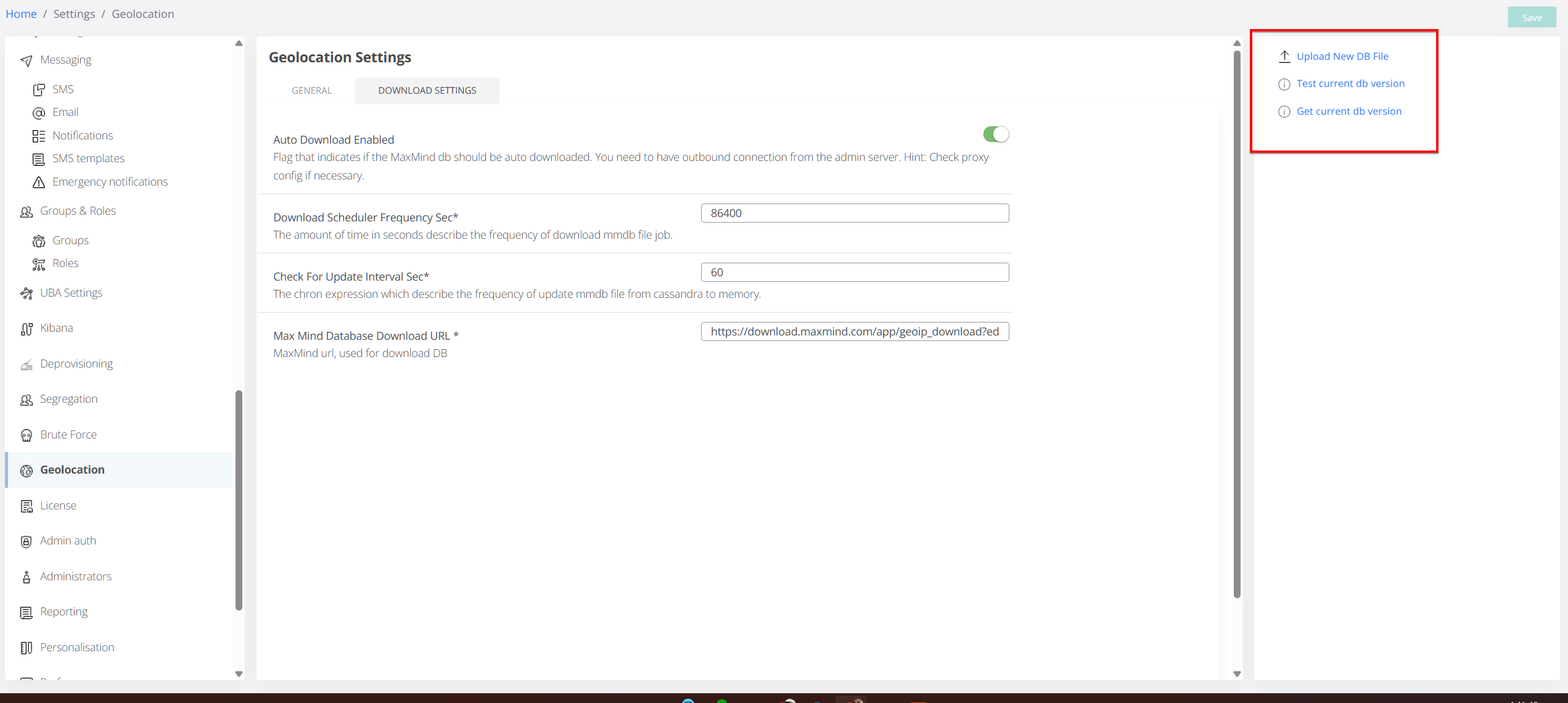
Geolocation - Download Settings Tab:
This tab provides control over the geolocation database, which is used to resolve location coordinates.
-
Database Management:
-
Update Frequency: Configure how often the geolocation database is automatically updated.
-
Download URL: Specify the URL from which the geolocation database is downloaded.
-
Manual Upload: Upload a custom geolocation database file.
-
Database Testing: Test the currently loaded geolocation database to ensure its functionality.
-
Version Information: View the current version of the loaded geolocation database.
-
-
API Usage:
-
Veridium Manager utilizes the MaxMind API to resolve location coordinates.
-
Key Functionality:
-
Granular Control: Administrators can precisely configure geofencing parameters to meet their specific security and operational requirements.
-
Database Management: The ability to manage the geolocation database ensures accurate location resolution.
-
MaxMind API Integration: Leveraging the MaxMind API provides reliable and up-to-date geolocation data.
Important Considerations:
-
Ensure that the geolocation database is regularly updated to maintain accuracy.
-
When uploading custom databases, verify their integrity and compatibility.
-
Review and adjust geofencing parameters based on evolving security needs.
Troubleshooting:
-
Location Resolution Common Error Codes:
|
Error code |
Error message |
Details |
|
1053 |
Failed to geocode the location |
The coordinates have been received, but they are not translated to a map position by the MaxMind API. |
|
1054 |
Location services is unavailable |
The mobile app cannot communicate with phone’s location mechanism (i.e Google Mobile Services Location) |
|
1055 |
Location permission denied for app |
The mobile app does not have location permissions allowed from the OS. |
|
1056 |
Timeout getting location |
All location services and permissions are working, but no location data is collected and received by application inside of the session timeout window. |
|
0 |
Location was captured successfully |
Everything went well. |
-
Verify that the geolocation database is up-to-date.
-
Test the database to ensure it is functioning correctly.
-
Check the MaxMind API connection.
-
Incorrect Geofencing Behavior:
-
Review the settings in the "Geolocation - General Tab" to ensure they are configured correctly.
-
Verify mobile device location settings to make sure the Veridium mobile app has all the permissions required by the server settings.
-